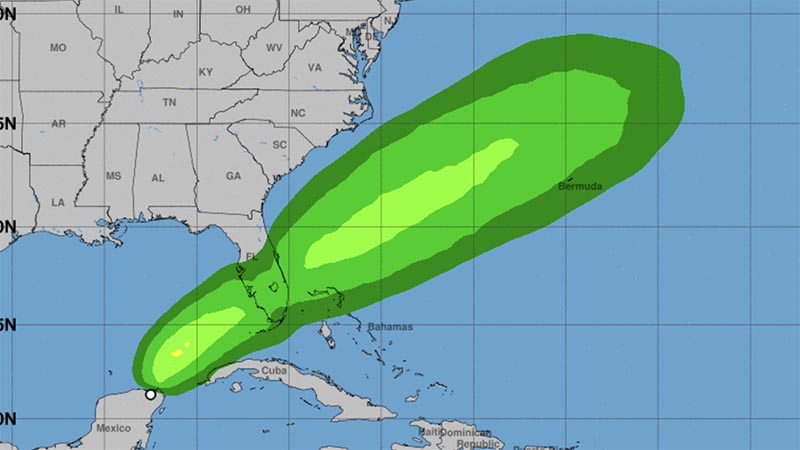
On Thursday, the National Hurricane Center designated an area of disturbed weather near the Yucatan Peninsula as Potential Tropical Cyclone One.
By Bryan Boggiano
The 2022 Atlantic Hurricane Season just began Wednesday, and the tropics are already brewing.
The National Hurricane Center designated an area of disturbed weather near the Yucatan Peninsula as Potential Tropical Cyclone One at 5 p.m.
Maximum sustained winds were estimated at 35 miles per hour, and the storm was moving north at 5 miles per hour. It is estimated to be 505 miles southwest of Fort Myers.
A potential tropical cyclone, or PTC, has no defined center of circulation, unlike a tropical storm or hurricane. The potential storm designation allows the NHC to issue advisories for systems that pose impacts to land.
As PTC One approaches South Florida, Tamarac officials prepare for the heavy rain, gusty winds, and possible flash flooding threats.
In an email directed to Mayor Michelle Gomez and the city commission, Information Technology Director Levent Sucuoglu discussed the forecast, preparations, and event cancelations ahead of Potential Tropical Cyclone One.
He mentioned that the city would cancel the planned Caribbean Family Fun Day on June 4. He discussed tentatively rescheduling the event to June 30.
City staff will lower canal levels before the storm system’s arrival and complete a full debris sweep throughout Tamarac through Friday. Staff will monitor debris and canal levels throughout the weekend.
The tropical system will approach Florida through Saturday and exit the peninsula by Saturday.
It is forecast to become Tropical Storm Alex and make landfall in Southwest or west-central Florida Saturday afternoon with winds up to 40 miles per hour.
A Tropical Storm Watch is in effect for Broward County, meaning that tropical-storm-force winds are possible within the next 48 hours.
Rain chances will increase Friday morning and afternoon, and heavy rain bands will overspread South Florida during the evening hours.
The National Weather Service in Miami predicts anywhere between 4 and 8 inches of rain is possible in this time window. Some places could see up to 12 inches of rain through Saturday night.
The chances for flooding are elevated considering that the ground is saturated from recent elevated rainfall. As a result, a Flood Watch is in effect for South Florida.
The rainfall forecast is subject to change depending on the storm’s final track over the state.
As with any landfalling tropical cyclone, there is a risk of tornadoes. The Storm Prediction Center has placed South Florida under a marginal risk, level one out five, of seeing isolated tornadoes late Friday and early Saturday.
The system is forecast to be lopsided, with most activity to the east of the center. This is because of strong wind shear and dry air in the Gulf of Mexico, which will prevent significant strengthening.
The storm will clear the area by early Sunday when the typical pattern of scattered afternoon thunderstorms will resume.
Got News? Send it to Tamarac Talk.
Author Profile
Latest entries
 NewsOctober 1, 2023Heated Competition and Controversy Brew in 2024 Tamarac Elections
 NewsSeptember 22, 2023Students Get a Chance to Shine in the 2023 Congressional App Challenge
 NewsAugust 1, 2023Florida Education Standards Under Fire: Bipartisan Leaders Join Rep. Cherfilus-McCormick in Condemning Revisionist History on Slavery
 NewsJuly 27, 2023Rep. Sheila Cherfilus-McCormick Champions Act Addressing Violence in Haiti


